Somewhere between the third and fourth creek crossing on the West Fork trail, the hike stops feeling like a hike. The canyon walls have narrowed to a couple hundred feet. The cottonwoods and Arizona sycamores close overhead. The only sounds are water moving over rocks and the occasional canyon wren. Most people who hike it once come back for the leaves in October. Most people who move to Sedona, Arizona eventually make it a seasonal ritual, the kind of thing that marks the year the way seasons do for people who pay attention.
West Fork is the most searched canyon hike in Arizona and the most consistently recommended trail in the Sedona area by people who have been here long enough to have opinions. That consensus is earned. Here is what to actually expect.
Where West Fork Trail Is and How to Get There
West Fork Trail is located in Oak Creek Canyon, approximately 11 miles north of Uptown Sedona, Arizona via Highway 89A. The trailhead is at Call of the Canyon day use area on the west side of the highway. The drive from Uptown Sedona takes approximately 20 to 25 minutes under normal traffic conditions. The canyon road itself on Highway 89A is one of the more scenic drives in Arizona, switchbacking through the ponderosa pine transition zone as the elevation rises from Sedona’s high desert toward the Mogollon Rim.
Day use fees apply at Call of the Canyon. The current fee is $12 per vehicle as of 2026. The America the Beautiful annual pass covers this fee, which makes it one of the more valuable use cases for annual pass holders in the Sedona area. Payment at the self-serve kiosk near the parking area is required regardless of how long you stay.
The parking lot at Call of the Canyon holds approximately 100 vehicles and fills by 9 AM on weekends during spring (March through May) and fall (September through November). On peak spring and fall weekends, arriving before 8 AM is the reliable strategy. The lot does not typically fill on weekdays except during holiday weeks.
There is no alternate trailhead for West Fork. If the lot is full, the options are to wait for a space to open or return on a different day. Ride-share drop-offs at the lot entrance are permitted and are an increasingly common approach for visitors who want to avoid the parking problem.
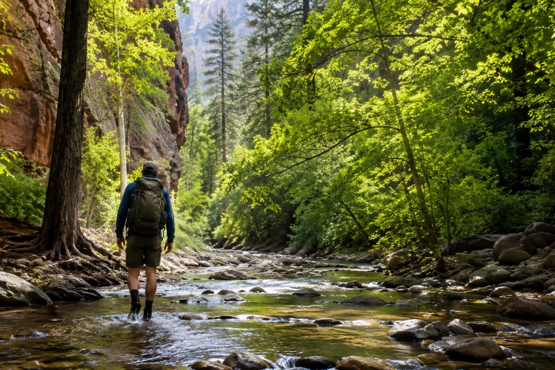
The Hike: What West Fork Is and Is Not
West Fork is a canyon walk, not a summit hike. There is no peak, no arch, and no single dramatic viewpoint at the end. The experience is the canyon itself: the walls, the water, the vegetation, the light. Understanding this before you arrive sets the right expectation. Visitors who arrive expecting a dramatic formation panorama find something more immersive and more intimate. Visitors who arrive knowing what West Fork is find one of the more consistently rewarding trail experiences in Arizona.
The maintained trail extends approximately 3 miles one way, or 6 miles round trip. Total elevation gain on the maintained section is minimal, approximately 200 feet across the full round trip. This makes West Fork one of the most physically accessible significant hikes in Sedona, Arizona. People with knee or hip limitations that prevent them from hiking formation trails often find West Fork achievable when other Sedona hikes are not.
The trail begins on a wide, well-maintained path through the old Mayhew Lodge property before quickly entering the canyon where the walls narrow and the forest canopy thickens. The creek crossings begin within the first quarter mile. Over the 3-mile maintained section, the trail crosses the creek approximately 13 times. Beyond the maintained trail, the canyon continues for several more miles as a true slot canyon that requires wading to waist depth or above and should not be attempted without proper preparation.
The Creek Crossings: What to Expect and How to Prepare
The creek crossings are the defining feature of the West Fork hiking experience and the primary preparation question for first-time visitors. Here is what they are: unavoidable. The first crossing comes within a quarter mile of the trailhead. There is no way to complete this hike with dry feet.
Water depth at most crossings ranges from ankle deep to knee deep under normal spring and early summer flow conditions. After significant snowmelt from the Mogollon Rim, typically April through early June in a normal water year, the crossings can run deeper. After summer monsoon events, high water can temporarily raise crossing depths to thigh level or higher and may cause the trail to close temporarily.
The creek bottom is rocky with rounded stones. The rocks are slippery regardless of season. Moving water over rounded rocks requires attention to foot placement. Trekking poles are helpful for stability at the crossings and are used by a majority of experienced hikers on this trail.
Footwear: sandals or dedicated water shoes are the correct choice. Hiking boots will be saturated within the first crossing and remain uncomfortably wet for the remainder of the hike. Lightweight trail runners that dry quickly are a reasonable alternative. Flip flops provide insufficient support for the rocky creek bottom. Open-toe sandals with straps work better than flip flops but are not ideal. The commitment to wet feet from the first crossing is the correct mindset.
Fall Colors at West Fork: Why October Changes Everything
West Fork in October is one of the most dramatically photographed places in Arizona, and the photographs do not exaggerate what is actually there. The canyon’s mix of Arizona sycamore, bigtooth maple, velvet ash, cottonwood, and box elder trees turns the walls gold, orange, and red against the backdrop of the red and white sandstone formations above. The color peaks typically in mid-October through early November depending on the year’s temperatures.
The combination of fall leaf color reflected in the canyon creek pools and the red rock formations above is genuinely extraordinary. It draws visitors from across the state specifically for the color, which means peak weekend days in mid-October approach the capacity of peak spring weekends. Planning around this is worthwhile: a weekday visit in mid-October often delivers the same color peak with a fraction of the trail traffic.
Winter visits to West Fork in December through February provide the quietest experience on this trail across the full calendar year. The canyon in winter light, with bare sycamore branches against white sandstone walls and the creek running cold and clear, is a fundamentally different visual experience from the summer and fall visits. Some of the most experienced West Fork visitors consider the winter version of this hike the most underrated experience in the Oak Creek Canyon corridor.
What to Know About the Extended Canyon
Beyond the maintained 3-mile trail endpoint, West Fork continues as a slot canyon for several additional miles before the canyon becomes impassable. This extended section is a genuinely different experience: waist-deep or deeper wading, technical route finding, and no maintained trail markers. It requires different preparation and a different commitment level than the standard hike.
For visitors interested in the extended canyon, the key information is: the water is cold year-round, ranging from approximately 50 to 58 degrees Fahrenheit even in summer, and the depth in the slot sections can reach chest height or more at some pinch points depending on the water year. A permit is not currently required for the extended canyon section, but this has been subject to discussion and should be verified before planning an extended canyon trip.
The maintained trail is what most visitors experience and what most trip reports describe. The extended canyon is a separate undertaking that requires separate planning.
Oak Creek Canyon Property and West Fork Access
Properties within Oak Creek Canyon, Sedona, Arizona have direct access to West Fork via a short drive north on 89A. The canyon has very limited residential inventory, primarily older cabins, cottages, and a small number of larger properties on restricted lots within the canyon corridor. National Forest ownership of the surrounding land means no new development is possible beyond the existing footprint of private lots in the canyon.
When properties within the canyon come to market, they move quickly and with competitive interest from buyers who have specifically identified canyon living as their priority. Angelo Davis, REALTOR® at RE/MAX Sedona, monitors Oak Creek Canyon inventory for buyers who are targeting this corridor and understands the specific characteristics of these properties, including the highway adjacency, the seasonal creek behavior, and the Forest Service adjacency rules that affect what owners can and cannot do with these parcels.
Frequently Asked Questions
How long is West Fork trail in Oak Creek Canyon?
The maintained West Fork trail in Oak Creek Canyon, Sedona, Arizona is approximately 3 miles one way, or 6 miles round trip. Most hikers complete the round trip in 3 to 4 hours including time at the creek crossings and the canyon sections. The trail involves approximately 13 creek crossings and approximately 200 feet of total elevation gain across the full round trip.
Do you get wet hiking West Fork trail in Sedona?
Yes. West Fork trail in Sedona’s Oak Creek Canyon involves creek crossings beginning within a quarter mile of the trailhead. Water depth ranges from ankle to knee deep under normal flow conditions. Wet feet from the first crossing are unavoidable. Sandals or water shoes are strongly recommended. Anyone who wants to keep their feet dry cannot complete this hike.
When is the best time to hike West Fork in Sedona?
West Fork trail in Sedona, Arizona offers two peak seasonal experiences: spring through early summer when the water is flowing and the canyon vegetation is lush, and mid-October through early November for fall leaf color. Summer is warm but the canyon shade makes morning visits comfortable. Winter visits provide the quietest experience and a dramatically different visual character.
Is West Fork trail crowded in Sedona?
West Fork trail is among the most visited trails in Sedona, Arizona. The parking lot fills by 9 AM on spring and fall weekends. Weekday visits throughout the year offer significantly lower traffic. A pre-8 AM weekend arrival during peak season provides parking and a noticeably less crowded trail experience, particularly in the first mile near the trailhead.
How much does it cost to park at West Fork trail Sedona?
The day use fee at Call of the Canyon, the trailhead for West Fork in Oak Creek Canyon, Sedona, is $12 per vehicle as of 2026. The America the Beautiful annual federal lands pass is accepted and covers the fee. Fees are subject to change and should be verified at recreation.gov before your visit.
Are dogs allowed on West Fork trail in Sedona?
Dogs are not permitted on the West Fork trail in Oak Creek Canyon, Sedona, Arizona. This restriction is a Coconino National Forest Special Management Area designation that protects the riparian habitat of the canyon. The restriction applies to the full length of the trail from the Call of the Canyon trailhead.
—
Share this with someone who has been researching Sedona trails and keeps finding the same five hikes on every list. West Fork changes what that list looks like.