People who move to Sedona, Arizona full-time tend to stop hiking Devil’s Bridge after the first year. Not because the arch loses its appeal, but because they discover Soldier Pass. It has everything that makes Devil’s Bridge worth doing, plus erosion sinkholes, a cave system, natural water pools that fill seasonally after rain, and a fraction of the daily visitor count. The reason most tourists never find it is that it has no single iconic photograph that drives social media traffic.
That is precisely what makes it worth knowing about. The trail rewards people who are looking for the complete Sedona red rock experience over people who are looking for a specific shot. And it sits in one of the most residential sections of West Sedona, surrounded by neighborhoods rather than the open desert corridor that characterizes the more tourist-dense trail networks.
Where Soldier Pass Is and How to Get There
Soldier Pass trailhead is located in West Sedona, Arizona, accessed via Soldier Pass Road off Jordan Road. From the Y intersection, head west on Highway 89A, turn right onto Jordan Road heading north, then follow signs to the Soldier Pass trailhead. The trailhead parking area is small, approximately 20 spaces, and fills quickly on weekend mornings.
The Red Rock Pass is required for parking at $5 per vehicle. A second access point via Brins Mesa Road on the northeast side of the trail system provides alternative access and is often less crowded than the primary Soldier Pass Road trailhead. Both connect to the same trail network and the same geological features. The drive from central West Sedona takes approximately 10 minutes to the Soldier Pass Road trailhead.
For residents of the neighborhoods near Jordan Road and Soldier Pass Road, this trailhead is genuinely walkable. Some West Sedona streets put you within a 10-minute walk of the trailhead parking area, which makes this a functionally different daily trail experience than trails requiring a drive.
What the Soldier Pass Trail System Actually Contains
The Soldier Pass trail is technically a 4.2-mile loop with approximately 500 feet of elevation gain, but describing it as simply a loop undersells what the route passes through. This trail contains four distinct geological and natural features that most Sedona hikes do not offer in a single route.
The first is the Devil’s Kitchen sinkhole, encountered shortly after the trailhead. Devil’s Kitchen is a natural collapse in the Hermit Shale formation approximately 150 feet across and 100 feet deep. A fenced overlook provides a safe view into the void. The ground around the sinkhole is genuinely unstable. The fence exists for a reason. The sinkhole continues to expand slowly as additional collapses occur, and it is monitored periodically. The visual impact is significant: a sudden hole in the sandstone desert that has no equivalent elsewhere in the immediate Sedona trail network.
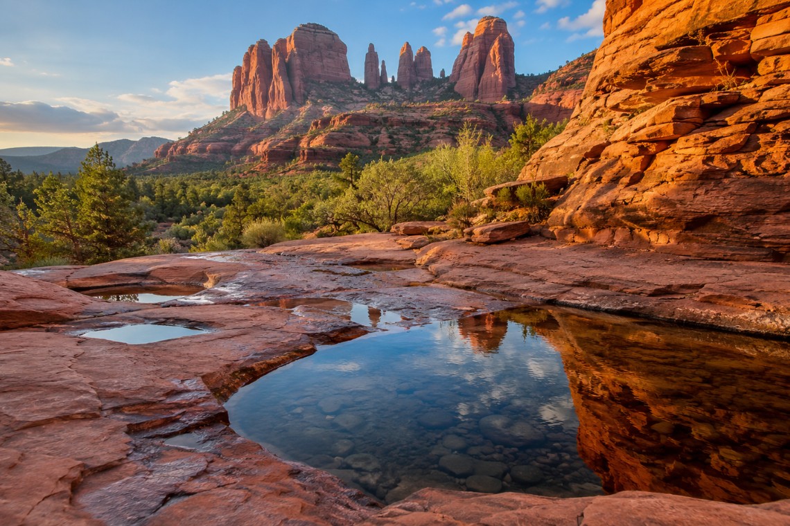
The second is the Seven Sacred Pools, a series of natural stone basins carved by water erosion in the creek bed approximately one mile from the trailhead. The pools are flat-bottomed depressions in the bedrock, ranging from dinner-plate size to several feet across and up to two to three feet deep when holding water. After significant rainfall, they fill and reflect the surrounding red rock formations in their still surfaces. In early morning light in late winter or early spring after a wet season, the reflections in these pools are genuinely beautiful in a way that is different from any other visual experience on the Sedona trail network.
The third feature is Soldier Pass Cave, a large natural alcove in the canyon wall approximately one mile from the primary trailhead. The cave mouth is wide enough to walk into without ducking. The interior extends perhaps 30 to 40 feet deep with a smooth sandy floor. The cave provides a sheltered view of the canyon and the red rock formation landscape beyond. It is a natural rest point, cool in morning shade, and dramatically quiet even when the trail has moderate traffic.
The fourth element is the ridge and formation terrain itself, which in this section of West Sedona runs in tight sandstone ridgelines and narrow corridors that feel genuinely wild despite the residential neighborhood immediately adjacent. The trail is well-marked but the terrain changes character frequently, alternating between wide open wash crossings and tight passages between formation walls.
When the Seven Sacred Pools Have Water
The pools at Soldier Pass are seasonal, and understanding when to visit for water requires knowing something about how the Sedona precipitation calendar works. The Sedona area receives approximately 17 to 18 inches of annual precipitation, split between winter frontal storms from November through March and the monsoon season from July through September.
In a normal winter with adequate precipitation, the Seven Sacred Pools typically hold meaningful water from January through early April. By late April in an average year the upper pools begin to dry. By late May in most years all the pools are dry stone basins unless there has been late-season precipitation.
The monsoon season brings afternoon thunderstorms that can rapidly fill the pools again, but the pools typically drain within days to weeks after a monsoon event rather than holding water for extended periods as they do after winter soaks. The best single window for reliable pool water in Sedona, Arizona is February through late March following a normal or above-average precipitation winter.
Checking recent rainfall at the Sedona weather station before visiting in spring is the practical approach. A significant rain event in the preceding two weeks substantially increases the probability of finding water in at least some of the pools. In a dry year the pools may be empty by February.
The Loop vs. Out-and-Back Choice
The standard Soldier Pass route in Sedona, Arizona is a loop that returns via the Brins Mesa connector trail, completing a roughly circular route back to the primary or secondary trailhead. The loop format means you are always seeing new terrain rather than retracing your steps, which makes the total experience feel richer than the mileage alone suggests.
Some hikers do an out-and-back from the Soldier Pass Road trailhead, hitting Devil’s Kitchen, the Seven Sacred Pools, and the cave before returning the way they came. This shortens the total to approximately 2.5 miles round trip and is appropriate for visitors with limited time or anyone who wants to see the primary features without committing to the full loop.
The full loop is worth the additional distance. The Brins Mesa connector section passes through a different landscape character than the primary trail, with broader views of the West Sedona formation panorama visible once the trail climbs slightly above the canyon floor.
Soldier Pass for Buyers Evaluating West Sedona
The Soldier Pass area represents a specific character of West Sedona residential living that differs from the Dry Creek Basin corridor farther west. The neighborhoods immediately adjacent to the Soldier Pass trailhead, including streets off Jordan Road, Rim Shadows Drive, and the upper sections of Soldier Pass Road itself, are mature West Sedona residential areas with established homes and the genuine walkability to trailhead access that most Sedona properties claim but few actually deliver.
Angelo Davis, REALTOR® at RE/MAX Sedona, has worked with buyers specifically seeking this part of West Sedona for its combination of neighborhood character and immediate access to a trail system this varied. The trailhead’s limited parking naturally controls the crowd level at the trail, which means that residents who can walk to it have a meaningfully different daily experience than those who drive.
Properties on streets that provide this proximity are not necessarily the highest-priced in West Sedona, but they occupy a specific lifestyle niche that buyers who prioritize walking-distance trail access find uniquely valuable.
Frequently Asked Questions
How long is Soldier Pass trail in Sedona?
Soldier Pass trail in Sedona, Arizona is approximately 4.2 miles as a full loop with 500 feet of elevation gain. Most hikers complete the loop in 2 to 2.5 hours at a moderate pace. An out-and-back to the primary features (Devil’s Kitchen, Seven Sacred Pools, Soldier Pass Cave) is approximately 2.5 miles round trip.
What are the Seven Sacred Pools in Sedona?
The Seven Sacred Pools are a series of natural stone water basins carved by water erosion in the creek bed on the Soldier Pass trail in Sedona, Arizona, approximately one mile from the trailhead. They fill after rainfall and hold water most reliably from January through late March following adequate winter precipitation. By late spring in most years they are empty stone basins.
What is Devil’s Kitchen sinkhole in Sedona?
Devil’s Kitchen is a natural collapse sinkhole near the Soldier Pass trailhead in Sedona, Arizona, measuring approximately 150 feet across and 100 feet deep. It formed through the collapse of underground cave systems in the Hermit Shale formation and continues to expand slowly. A fenced overlook at the trail provides a safe view into the sinkhole.
Is Soldier Pass trail crowded in Sedona?
Soldier Pass is significantly less crowded than Devil’s Bridge or Bell Rock in Sedona, Arizona. The small trailhead parking area naturally limits daily visitor volume. The trail length and variety of features distribute hikers effectively. Weekday mornings are typically quiet. Weekend mornings in spring and fall have traffic but not the queue conditions that form at the most-photographed Sedona trailheads.
Is Soldier Pass trail dog friendly?
Dogs are permitted on Soldier Pass trail in Sedona, Arizona on a leash of 6 feet or shorter. The loop terrain is manageable for most dogs. Carry water for your dog on any visit from April through October when trail temperatures rise. The Soldier Pass Cave section involves a short scramble that most dogs handle without difficulty.
Where is Soldier Pass Cave in Sedona?
Soldier Pass Cave is a large natural alcove approximately 1 mile from the primary Soldier Pass trailhead in Sedona, Arizona, accessible via a short spur from the main trail. The cave mouth is wide enough to walk into and the interior extends roughly 30 to 40 feet deep. It provides a sheltered viewpoint and is a natural rest stop on the loop.
—
If this version of Sedona is the one that interests you, the residential streets near this trailhead tell a specific story about what daily life here actually looks like. One conversation is the right place to start.