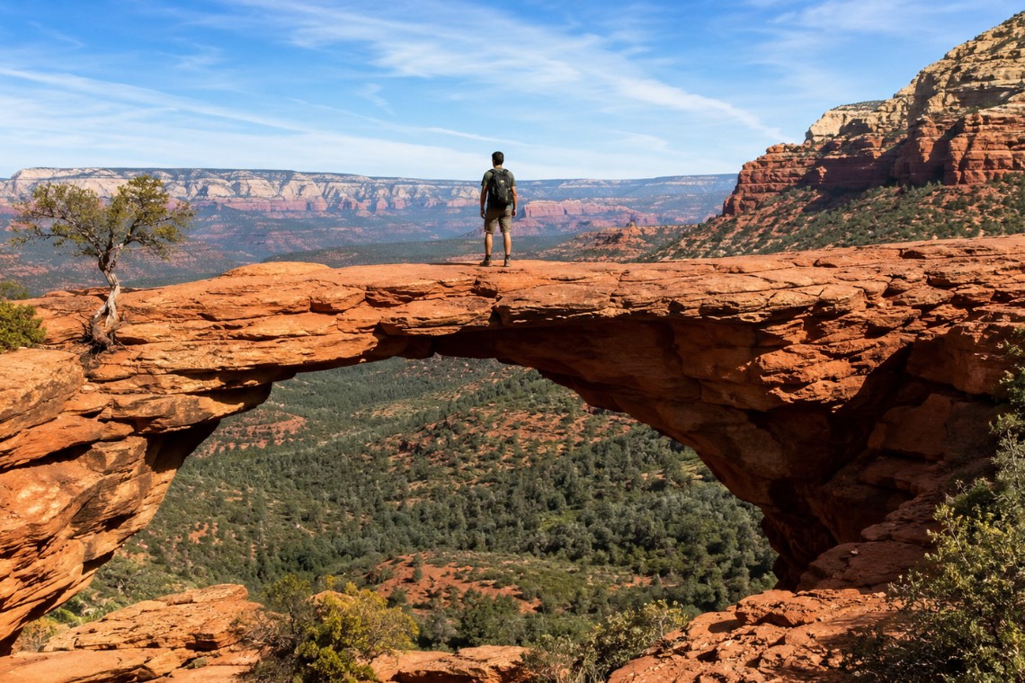
There is a photograph that has been taken roughly three million times. Someone stands on a narrow sandstone ledge above a canyon with their arms outstretched, the arch of Devil’s Bridge framing the sky behind them. What the photograph never shows is the forty-five-minute hike that precedes it, the final exposed ledge walk that requires actual attention, or the fact that the trailhead parking lot fills before 7 AM on weekends from March through November.
Devil’s Bridge is the most searched hike in Sedona, Arizona, and one of the most misunderstood. The arch is real, the view is genuinely spectacular, and the hike to reach it is well within the capability of most adults in reasonable fitness. But the experience that most visitors imagine and the experience that actually unfolds are different enough that preparation changes everything.
Where Devil’s Bridge Is and How to Get There
Devil’s Bridge sits in West Sedona, Arizona, accessed via Dry Creek Road off Highway 89A. From the Y intersection where Highway 179 meets 89A, head west on 89A for approximately 2.5 miles, then turn right onto Dry Creek Road heading north. The Mescal Trailhead is approximately 3.2 miles from Highway 89A. Signs for Devil’s Bridge are posted along Dry Creek Road.
There is a second access point via Long Canyon Road, which adds distance to the hike but typically has more available parking on crowded weekend mornings. Both trailheads require the Red Rock Pass. Day passes run $5 per vehicle and can be purchased at self-pay stations at the trailheads or in advance at recreation.gov. The America the Beautiful annual pass covers the fee and pays for itself quickly for anyone visiting multiple trailheads in the Sedona area.
For anyone asking whether there is a way to skip the parking problem entirely: the short answer is no. Ride-share drop-offs at the trailhead are permitted and have become more common on weekends. This is worth considering if you are staying in West Sedona for multiple nights and can plan around the timing.
The Hike: Distance, Elevation, and What the Trail Actually Involves
From the Mescal Trailhead, Devil’s Bridge is approximately 4.2 miles round trip with about 400 feet of total elevation gain. The trail follows a sandy wash for the first mile before transitioning to a red rock and loose dirt surface as it begins climbing through the lower Dry Creek Basin formations. There are no technical sections on the approach. The footpath is clear, well-worn, and marked with trail signs at intersections.
The Mescal Trail intersection is a point where some hikers turn onto the wrong path. Stay on the Devil’s Bridge trail at the signed junction rather than continuing on Mescal. The correct route begins climbing more steeply here, switchbacking through juniper and pinon forest before the sandstone becomes the dominant surface.
The final approach to the arch involves a short but unmistakable scramble up a series of natural sandstone steps. These steps are well-worn, roughly 18 to 24 inches each, and require using your hands in a few places. After the steps, the ledge walk begins. The ledge spans roughly 50 feet and narrows to approximately 4 feet at its tightest point. It sits above a significant drop on both sides. The surface is solid sandstone with excellent dry-day grip.
Most adults in reasonable fitness complete the round trip in 2 to 2.5 hours at a moderate pace. Faster hikers finish closer to 90 minutes. If you have knee or hip limitations that affect descent pace, add 30 minutes.
The Ledge Walk: What to Expect and How to Think About It
The ledge is the section of this trail that causes the most difficulty, and almost all of that difficulty is psychological rather than physical. The ledge itself is not technically demanding. It is wide enough to walk comfortably. The sandstone provides good traction. There are no loose rocks to navigate.
What it is: exposed. On both sides of the ledge there are significant drops. If you look straight down, there is nothing preventing a fall except your own balance and attention. This is the experience that sends some visitors back from the arch despite having hiked the full approach. That is a completely reasonable response. The ledge is optional. You can see the arch and understand its scale from the top of the scramble steps without walking out to the center.
For those who do walk the ledge: look ahead rather than down, walk at your own pace, and be aware that the ledge becomes congested when a group is ahead of you. The etiquette is to wait at the base of the scramble steps if there are already people on the ledge, then go when it clears. Passing on the ledge itself is possible but requires communication and awareness of the drop.
The Arch Itself: What You Are Looking At
Devil’s Bridge is the largest natural sandstone arch accessible on foot in the Sedona, Arizona area. The span measures approximately 54 feet across and rises 45 feet above the canyon floor below. It formed through differential erosion of the Schnebly Hill Formation sandstone, the same red rock layer that defines the visual landscape of West Sedona. Water and wind worked over millions of years along a vertical joint in the rock, gradually removing softer material until only the arch remained.
Standing on the arch provides a view across the Dry Creek Basin toward Secret Mountain Wilderness to the north, with the broader West Sedona residential area visible to the south and the Mogollon Rim visible on clear days. The arch itself feels substantially larger from below than from on top, which is a consistent observation among first-time visitors. From above, you are standing on a relatively narrow sandstone feature with a dramatic view. From below, looking up at the full span, the scale becomes apparent in a different way.
The best time of day for the arch from a photography standpoint is mid-morning, roughly 9 to 11 AM, when the eastern sun illuminates the arch face without harsh shadows. Late afternoon creates deep shadows in the canyon below that flatten the visual depth. Early morning has beautiful light quality but the arch face is in shadow until about 8:30 AM depending on season.
When to Go: Crowd Strategy and Seasonal Timing
Devil’s Bridge in Sedona, Arizona is one of the most trafficked trails in the state from February through May and again in October and November. Weekend mornings during these periods see the trailhead fill by 6:30 to 7 AM. Once the parking lot is full, visitors are directed to overflow areas farther down Dry Creek Road that add walking distance to the hike.
The single most effective strategy for a quality Devil’s Bridge experience is a weekday visit. Monday through Thursday outside of school vacation periods, the trail sees a fraction of the weekend traffic. A mid-week morning in April or October is a fundamentally different experience than a Saturday at 10 AM in the same month.
For weekend visits, arrival by 6:30 AM is the threshold for parking at the primary trailhead during spring and fall peak season. The trail from 6:30 to 8 AM has noticeably fewer people on both the approach and the ledge, which makes the arch experience meaningfully better. By 9 AM on a peak weekend day, the ledge has a queue.
Summer (June through early September) sees lower visitation despite being school vacation season because Sedona’s midday temperatures become uncomfortable for hiking. The trailhead does not fill as early, but the exposed slickrock sections get hot. Early morning summer visits (before 8 AM) are pleasant. Midday summer hikes are not recommended.
Winter visits in December through February offer the quietest experience. Temperatures are cool to cold. The arch in winter morning light against a blue sky is one of the less-documented but more rewarding seasonal experiences on this trail.
What to Bring and What Not to Skip
Water is the most critical item. The desert high desert environment at Sedona’s 4,300-foot elevation dehydrates faster than most visitors expect, particularly in dry months. Carry a minimum of 2 liters per person for the full round trip. In summer, carry more and drink before you are thirsty.
Sun protection is not optional on the exposed sections of this trail. The UV index at Sedona’s elevation is meaningfully higher than at sea level. Sunscreen, a hat with a brim, and sunglasses are standard equipment.
Footwear matters. Trail runners with a grippy outsole are appropriate. Hiking boots work. Regular athletic sneakers are functional on the packed dirt sections but less secure on slickrock. Open sandals are not appropriate for the scramble steps or ledge. Flip flops are a common regret at this trailhead.
There is no water available on the trail or at the trailhead. No restroom facilities at the Mescal Trailhead, though the Long Canyon Road trailhead has a portable toilet. Pack out everything you bring in.
Devil’s Bridge and West Sedona Real Estate
Buyers considering West Sedona homes frequently ask about trail access as a daily lifestyle factor rather than an occasional amenity. Devil’s Bridge, Mescal, Long Canyon, Fay Canyon, and Boynton Canyon trails are all accessible within a 10 to 15-minute drive of most West Sedona residential neighborhoods. Some properties in the Dry Creek Basin corridor, including neighborhoods near the Seven Canyons and Thunder Mountain areas, are within a few minutes of the Mescal Trailhead.
The ability to walk or make a short drive to a trail network of this quality is one of the specific lifestyle advantages that West Sedona, Arizona offers that photographs do not fully convey. Angelo Davis, REALTOR® at RE/MAX Sedona, works with buyers who are specifically evaluating properties for their trail proximity and can identify which West Sedona streets deliver that daily access most directly.
For buyers asking whether the Dry Creek Basin corridor is worth the trail access premium: the honest answer is that it depends on how central hiking is to your daily life. For buyers who hike several times a week, the difference between a 5-minute drive and a 20-minute drive to a trailhead adds up over the course of a year in a way that affects whether the trail actually gets used.
Frequently Asked Questions
How hard is Devil’s Bridge trail in Sedona?
Devil’s Bridge in Sedona, Arizona is rated moderate. The round-trip distance is approximately 4.2 miles with 400 feet of elevation gain. The approach trail is straightforward on packed dirt and sandy wash surfaces. The final section involves a short scramble up natural sandstone steps and a ledge walk to the arch that is technically easy but exposed. Most adults in reasonable fitness complete the hike in 2 to 2.5 hours.
Do I need a permit for Devil’s Bridge Sedona?
Devil’s Bridge does not require an advance hiking permit as of 2026, but a Red Rock Pass is required for trailhead parking. Day passes are $5 per vehicle, available at self-pay kiosks at the trailhead or in advance at recreation.gov. The America the Beautiful annual pass covers this fee. Permit requirements for Sedona trails have changed in recent years and should be verified before your visit.
What time should I arrive at Devil’s Bridge to avoid crowds?
Arrive at the Devil’s Bridge trailhead by 6:30 AM on weekends during peak season (February through May, October and November) to find parking at the primary lot and encounter fewer people on the trail and ledge. Weekday visits from Monday through Thursday offer significantly lower traffic throughout the day. Summer visits before 8 AM are comfortable before the heat builds.
Is Devil’s Bridge dog friendly?
Dogs are permitted on Devil’s Bridge trail in Sedona, Arizona and must be on a leash no longer than 6 feet at all times. The trail terrain is manageable for most dogs on the approach. The scramble steps and ledge walk at the arch are more challenging for large dogs and their handlers simultaneously. Many dog owners choose to observe the arch from the top of the scramble steps rather than taking their dog onto the exposed ledge.
Can beginners hike Devil’s Bridge in Sedona?
Fit beginners can complete the Devil’s Bridge hike in Sedona, Arizona. The distance and elevation gain are within reach for most adults who walk regularly. The section that requires honest self-assessment is the ledge walk at the arch. Hikers who are uncomfortable with heights or narrow exposed paths should be aware of this section before committing. Turning back at the scramble steps is always an option and does not require navigating the exposure in reverse.
What is the parking situation at Devil’s Bridge trailhead?
The Mescal Trailhead for Devil’s Bridge fills early on weekends in spring and fall, sometimes before 7 AM. The Long Canyon Road trailhead provides an alternative with typically more available parking but adds roughly 1.5 miles to the total hike. Both require the Red Rock Pass. Overflow parking areas along Dry Creek Road add walking distance. Arrive early or plan a weekday visit during peak season.
Is there water on the Devil’s Bridge trail?
There is no water available on the Devil’s Bridge trail or at the Mescal Trailhead in Sedona, Arizona. Carry a minimum of 2 liters per person for the full round trip. The dry high desert air at elevation dehydrates faster than most visitors expect. In summer months when trail surface temperatures are significantly higher than air temperature, carry more water than you think you will need.
—
If you are evaluating West Sedona neighborhoods and trail access is part of what you are looking for, search current Sedona listings to see what is available close to this trailhead corridor.
